Embracing mixed-use urban planning is a solution to pressing urban problems such as car dependency, loneliness, mental health concerns, increasing environmental footprint and the decline of small businesses.
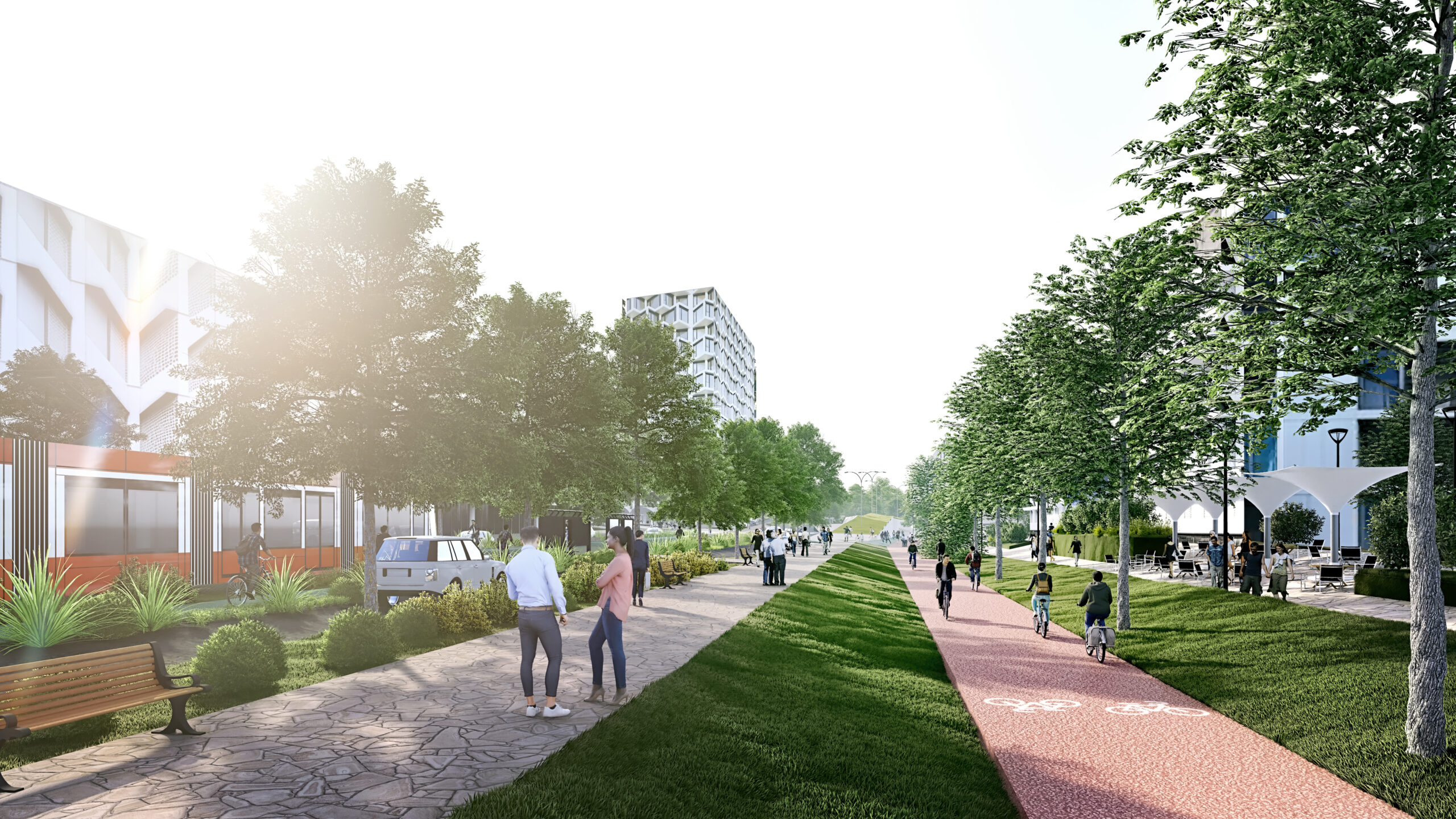
In a mixed-use urban environment, commercial, residential, cultural, institutional, and other functional spaces coexist side by side and layer upon each other. This means that in one area, one can live, work, take a child to kindergarten, visit a hairdresser, enjoy an art exhibition, and casually meet a neighbour in a cafe.
Such an environment is not only practical but also more sustainable in every aspect compared to a dispersed city where residents commute between different parts of the city daily.
Mixed use supports:
– using city resources more sustainably,
– creating an environment that is more relatable to individual needs and interests,
– creation of social space,
– cycling and walking, while also boosting public health.
It’s crucial not to confuse this layering, emphasising diversity, with stacking, which concentrates similar functions.1 The opposite of mixed use includes examples such as shopping villages, residential areas and concentrated business campuses, where a large area is characterised by a single purpose – perhaps many offices of different companies, but all still just offices.
People tend to go to these areas for a single purpose – whether it’s for office hours, to do some shopping, or to eat and sleep. At other times, however, there is no reason to go there at all. This inevitably leads to people being forced to travel daily from one end of the city to the other – especially given the lack of convenient public transport or cycle paths – and resorting to driving cars.
This was the original way
From a historical perspective, mixed use is nothing new – most city centres are mixed use urban spaces. In the Middle Ages, the city boundary was defined by the city walls, with markets, squares or churches in the heart of the city, and different functions such as schools, trading, manufacturing and housing mixed together. Mixed use was largely abandoned with industrialisation in the 19th and 20th centuries, as labour productivity increased and rural residents moved to the city, leading to rapid urban expansion.2 With the increase of car use and ownership, modern suburbs of single-family homes began to form. Over time, larger industries moved out of the city due to pollution, and commerce also moved to separate complexes away from the city centre. In this way, different zones began to form.
While it was initially convenient to have similar functions in one place, it has become clear that a scattered city creates daily commuting, which leads to car ownership. However, car dependency is neither economically nor socially sustainable and is destructive to the natural environment. It also hurts our mental and physical health.34 Mixed-use developments offer a solution to these problems, by generally being more human-centred, vibrant and dynamic urban spaces.
Foreign best practices include the Vauban district in Freiburg, Germany, or one of several Swedish examples – the Södermalm district in Stockholm, the Aker Brugge district in Oslo, or the B001 district in Malmö. The closest example is the Kalasatama area under development in Helsinki.
There is no good example of a mixed-use area in Estonia. Central Tallinn, together with the surrounding districts, is mostly grouped by function – in the centre of the city, shopping centres, hotels and offices define local areas. Residential areas such as Kassisaba, Uus Maailm and Kadriorg are concentrated around the city centre. There is no pleasant and comprehensive mixed-use urban space.
However, when thinking of Tallinn’s Golden Circle, i.e. the municipalities around the capital, or Mustamäe, Lasnamäe, Õismäe, the list of functions becomes even tighter. It is from these areas that people mainly go to work, school, kindergarten, shop and enjoy culture in the city centre. 5
“Kui linn elukeskkonnana ei paku vabadust valida liikumise viisi, kiirust ega vahendit, kui kõik esmavajalik ei ole käe-jala juures, kaotab linn eelise teiste elukeskkondade ees. Kevadel valminud Tallinna pika vaate rände- ja rahvastikuprognoos juba näitab, et Tallinnast maale kolimine on tõusuteel,” kirjutab ka Tallinna strateegiakeskuse ruumiloome tiimi juht Kaidi Põldoja.6
Streets have more to offer
Street serves as an important meeting place that fosters interpersonal communication. As people lead increasingly private lives – with their own homes, cars and offices – solitude becomes more common. 7
“Walking means much more than just walking,” says Danish architect Jan Gehl in the book “Cities for People”. Walking isn’t just a means of transport; it’s an opportunity to socialise, to gather information, to experience nature, to breathe fresh air, to engage in necessary physical activity, and to enjoy a variety of pleasant encounters and entertainment.
Encouraging walking and cycling also benefits businesses.8 A person strolling down the street is curious and open to new experiences, making connections with their surroundings. They have the flexibility to stop at any time and easily enter a shop or café.
Multifunctional urban spaces bring together people who would otherwise be scattered in different places, broadening social horizons and reducing isolation. This socialisation takes place between employees, visitors and residents, and forms the basis for the creation of a diverse community.9 Increased contact between members of different social groups fosters trust, mutual consideration and a reduction in prejudice.10
While business campuses typically close at 5pm, mixed-use developments keep gyms, cafes and bars open until late. This extended activity contributes to increased pedestrian traffic, making the areas safer.
The disadvantages of a fragmented urban space consisting of monofunctional areas were particularly evident during the COVID-19 pandemic. Cafes and small businesses in office districts struggled as remote working reduced the need for office visits, leaving whole areas seemingly deserted and customers disappearing.
A well-designed, versatile space
When planning a mixed-use district, it’s crucial to assess the existing elements and identify the missing components. In the case of Hundipea, our significant advantage is the opportunity to plan a large area almost from scratch, allowing a focus on the necessary functions and their proportions within the area. For example, due to the large number of residents but relatively few jobs in Kopli, our plan allocates about 60% of the area to commercial space and 40% to residential. The initial survey of interest groups in Northern Tallinn, conducted in collaboration with the Center for Applied Anthropology of Estonia, revealed a desire for improved access to the sea and increased availability of everyday services, including leisure and sports facilities, various grocery stores, and even hair salons. Additionally, Hundipea is planned to include a school and kindergartens.
By bringing different functions to the area we aim not only to revitalise the current industrial zone, but also to enhance the wider Paljassaare area. Over the next few decades, this emerging new centre will bring several services traditionally available only in the city centre closer to the community. Diversification of the population is also crucial for a thriving urban area, and to achieve this, we plan housing at different price points. Hundipea aims to avoid becoming a hub for “exclusive seaside apartments”, recognising that local professionals, such as a teacher or a firefighter, should be able to afford housing in nearby streets rather than commuting from the other end of the city every morning.
We are using digital twin to enable science-based planning and subsequent monitoring of the optimal placement of various functions to ensure maximum convenience and practicality for residents. If an area shows signs of stagnation or, conversely, becomes overcrowded, adjustments can be made and the urban space can be flexibly redesigned.
- Sim, D. Soft City: Building Density for Everyday Life (2019) ↩︎
- Silm, S. (2005) Tallinna linnaruumi funktsioonide ruumiline ja ajaline jaotus kesklinnas: vanalinna ja südalinna võrdlus ↩︎
- Hamidi, S., et al (2018) Associations between Urban Sprawl and Life Expectancy in the United States ↩︎
- Bruntlett, M., Bruntlett, C (2021) Curbing Traffic: The Human Case for Fewer Cars in Our Lives
↩︎ - Silm, S. (2005) Tallinna linnaruumi funktsioonide ruumiline ja ajaline jaotus kesklinnas: vanalinna ja südalinna võrdlus
↩︎ - Põldoja, Kaidi (2023) Kaidi Põldoja: tänavad on rohkemat kui linnast läbi liikumise koridorid, ERR.
↩︎ - Gehl, J. Cities for People (2010) ↩︎
- Schneidemesser, D., Betzien, J. (2021) Local Business Perception vs. Mobility Behavior of Shoppers: A Survey from Berlin ↩︎
- Sim, D. Soft City: Building Density for Everyday Life (2019) ↩︎
- Powers, S. L., et al (2022) The power of parks: How interracial contact in urban parks can support prejudice reduction, interracial trust, and civic engagement for social justice ↩︎