




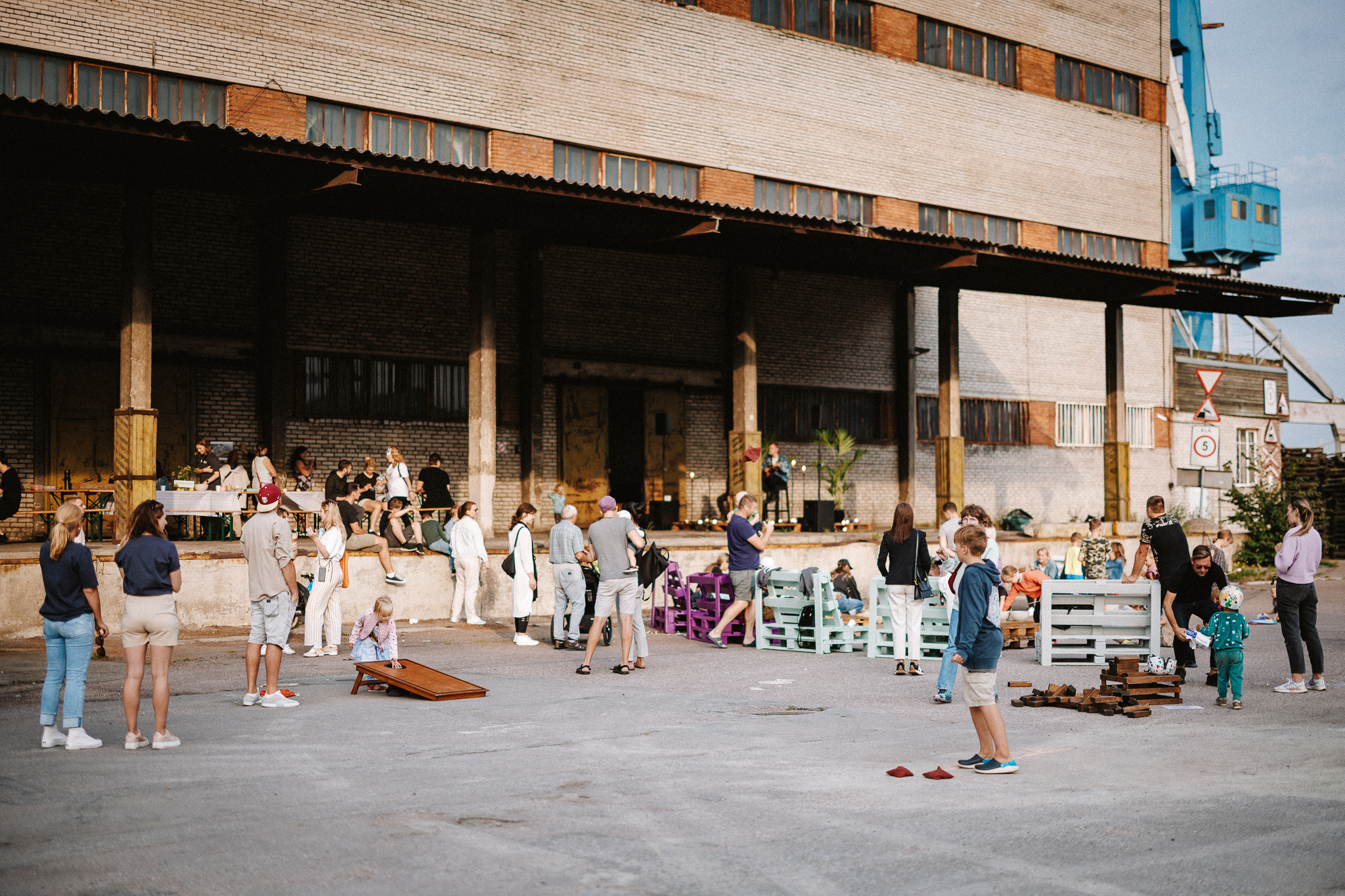
Streets are where neighbourhood life actually happens. People stop, meet, eat, play, rest and move through them every day. A few simple questions help us assess whether a street is any good. Can a child ride a bike there safely? Can someone with limited sight or mobility get around without assistance? Does it feel like a place worth spending time in, not just passing through?
At Hundipea, we start with those questions before we think about traffic. We ask what kind of life we want each street to support, and work out the movement from there.
In the Hundipea Neighbourhood Playbook, we describe walkable, accessible and well-dimensioned streets as the lifeblood of thriving neighbourhoods. Recognising the streetscape as the city’s largest public space, its quality shapes how easy it is for people to take part in neighbourhood life, to meet others, move around and feel at home. To translate these principles into the actual streets of Hundipea, we have developed a street design guide. It draws on Estonian standards and legislation as well as international references, including the NACTO Global Street Design Guide and the Tallinn Cycling Strategy. Like Hundipea itself, the guide will develop over time as we build, test and learn.
This blog article walks through the guide’s main principles and what they mean in practice.
Three street types
Not every street needs to do the same thing. Some are primarily for getting around, others for meeting people, letting children play, or supporting street-level commerce. Hundipea’s streets are organised into three types based on their role in the neighbourhood.
The promenade
We use the word “promenade” broadly here, not just as a seaside walkway, but as waterfront public space. The entire edge of Hundipea’s bay, currently fenced off as a working port, will eventually open up as roughly three kilometres of connected waterfront. Our starting point is that the sea should be a usable part of daily life, not just a view. Beyond movement routes, we are planning spaces for recreation, play and swimming along the water’s edge. The specifics will be worked out during the design process with landscape architects.
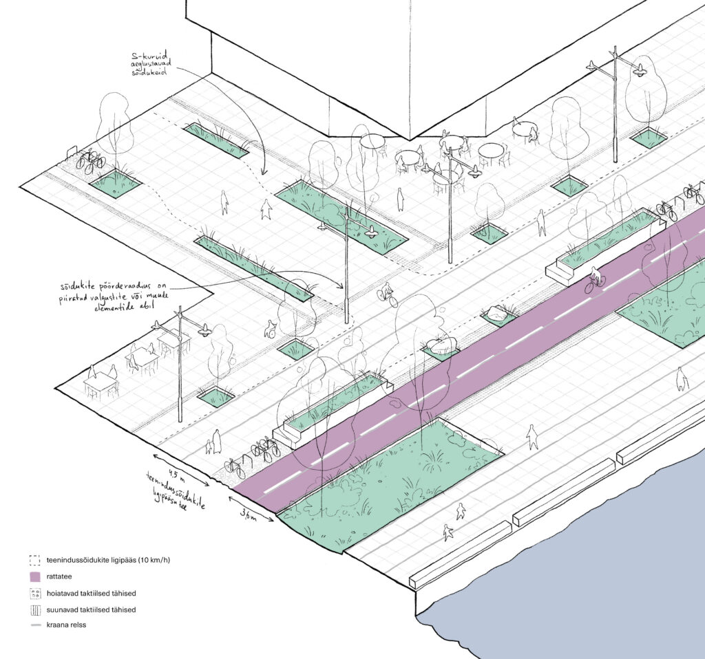
The promenade is made up of several zones. Closest to the water is a wide pedestrian area; next to it runs a two-way cycle path; and along the building line runs a shared street, primarily for pedestrians but accessible to service and emergency vehicles when needed.
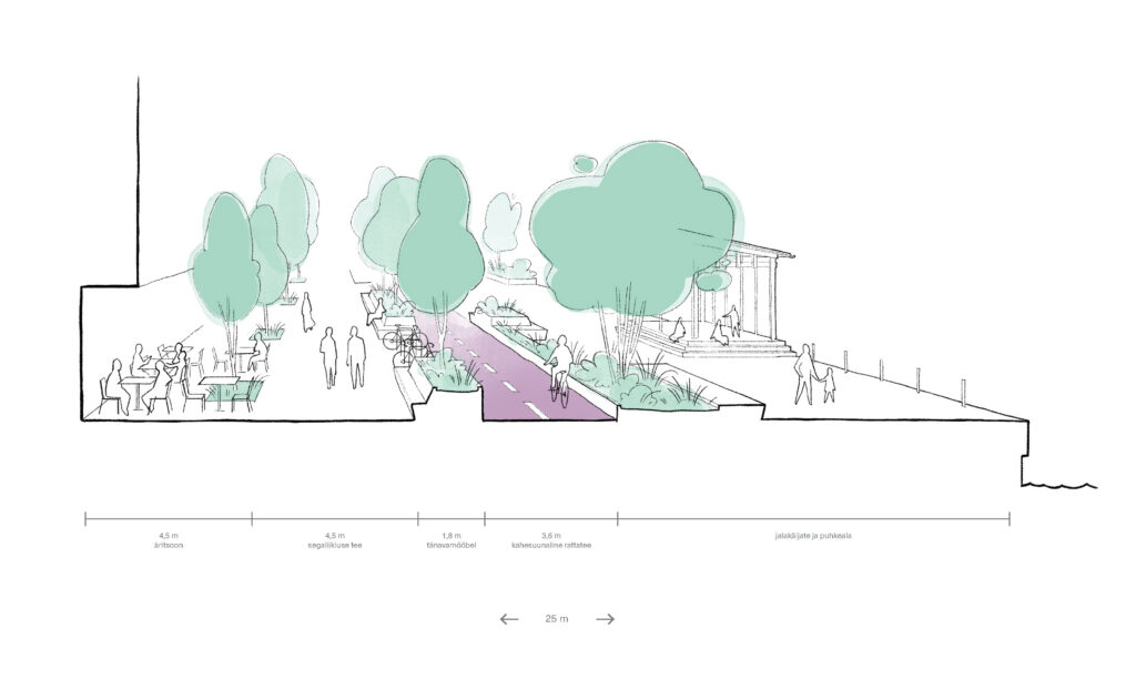
Emergency and service vehicles can access the promenade, but they are guests there. The design makes that clear, with paving stones rather than asphalt and no conventional kerbs or road markings. Street furniture and planting are the preferred means of creating informal separation and defining spaces, with sheltered spots and seating areas. The shared street can connect seamlessly to the frontage zone of cafés and shops along the buildings.
We also expect the promenade to be popular with cyclists, both as a link between Hundipea’s north and south shores and as a pleasant route for recreational riding. The likely volume and speed of cycle traffic means a dedicated cycle path is needed. Since the promenade has no roadway or complex intersections, a single two-way cycle path works cleanly here without creating problem areas. The recommended width is 2.5–4 metres, with 3.6 metres as the practical optimum.
The North Shore main street
The North Shore main street is the social and commercial backbone of the neighbourhood – the street with the highest footfall, active ground floors and the businesses that give a neighbourhood its daily rhythm. It is designed to accommodate bus traffic, with cycle paths separated from the roadway and a ground-floor frontage zone for cafés, shops and other businesses that help connect the street to what is happening inside the buildings.
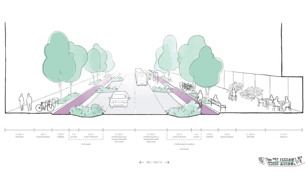
The speed limit on the main street is 30 km/h. To reinforce this, we are keeping lane widths tight (3–3.3 metres) and avoiding wide turning radii at junctions. One-way cycle paths run along both sides of the street, separated from traffic by planting, kerbs or buffer strips. Dense planting is particularly important on an active street like this, absorbing noise and creating a physical buffer between cyclists, pedestrians and vehicles.
Trees can be planted in the street furniture zone, in the rain garden islands between parking spaces, or in both locations at once. That last option creates a cycle path alley and gives the clearest visual separation between traffic zones.
Neighbourhood streets
Neighbourhood streets are narrower streets whose main function is access to residential buildings. Pedestrians are the primary users; there is no public transport.
These streets are often the closest public space to someone’s front door, where people run into their neighbours, children play and time passes slowly close to home. We are planning them with generous planting, seating and small public spaces that make them worth lingering in, not just walking through.
Narrow streets without a centreline naturally keep speeds low, as drivers have to yield to oncoming traffic and move carefully. The target speed limit is 20 km/h. Where possible, raised crossings reinforce this, giving pedestrians clear priority and signalling to drivers that they are entering a different kind of space.
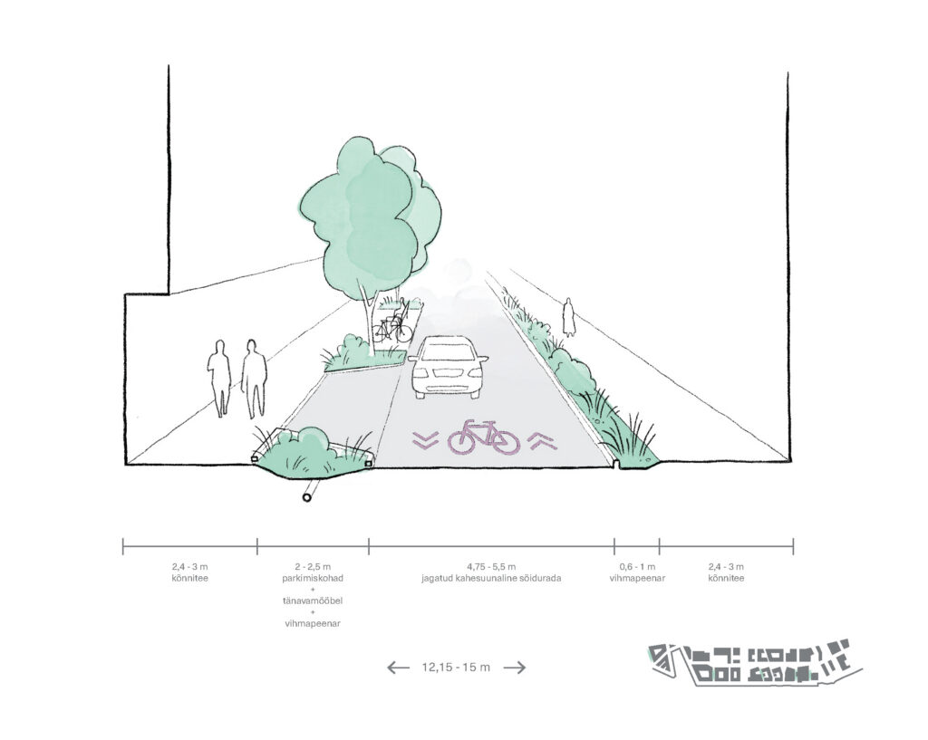
On the narrowest streets, where there is no room for a separate cycle path and motor traffic is light, we use a mixed traffic roadway. Cyclists have priority; the surface, typically cobblestones rather than asphalt, signals to drivers that this is not a normal roadway. In the Netherlands this is known as a Fietsstraat; in Germany as a Fahrradstraße. The surface is often the same colour as local cycle paths, traditionally red.
Some neighbourhood streets are pedestrian streets with no roadway at all. Even these need a clear path of at least 3.5 metres wide to allow emergency vehicle access if needed.
Planting as infrastructure, not decoration
Trees and shrubs do real work in street space: they act as a traffic buffer, absorb noise, improve air quality, regulate microclimate and manage stormwater through rain gardens. We plan roadways at minimum width partly to leave more room for planting, as it is not an afterthought.
Where trees and shrubs are placed in a cross-section reflects what they need to do in that specific location, whether creating a physical buffer between traffic and pedestrians, reducing noise from a busy road, or channelling rainwater.
Trees can sit in the street furniture zone at the edge of the sidewalk, in the strip between the cycle path and the roadway, or in both positions at once. That last option creates a cycle path alley and gives the clearest visual separation between traffic zones. The busier and faster the road, the more important this buffer becomes.
Surface materials as wayfinding
Surface material is not just a technical choice, it is one of the main tools for making a space legible. We use different surfaces for different zones so that people can read the space without having to think about it. When asphalt gives way to cobblestones, a driver understands they have entered a slower, quieter street. When small paving stones give way to large concrete slabs, a pedestrian senses they have arrived at a public space, a square or the promenade. The same logic applies in parks and play areas: gravel, timber decking or softer surfaces like wood chip communicate how a space is meant to be used.
Varied textures and materials also make public space more accessible, particularly for people with visual impairments, for whom surface changes and tactile contrasts are the primary way of reading a space and understanding where sidewalks, rest areas and road crossings begin and end.
Crossings
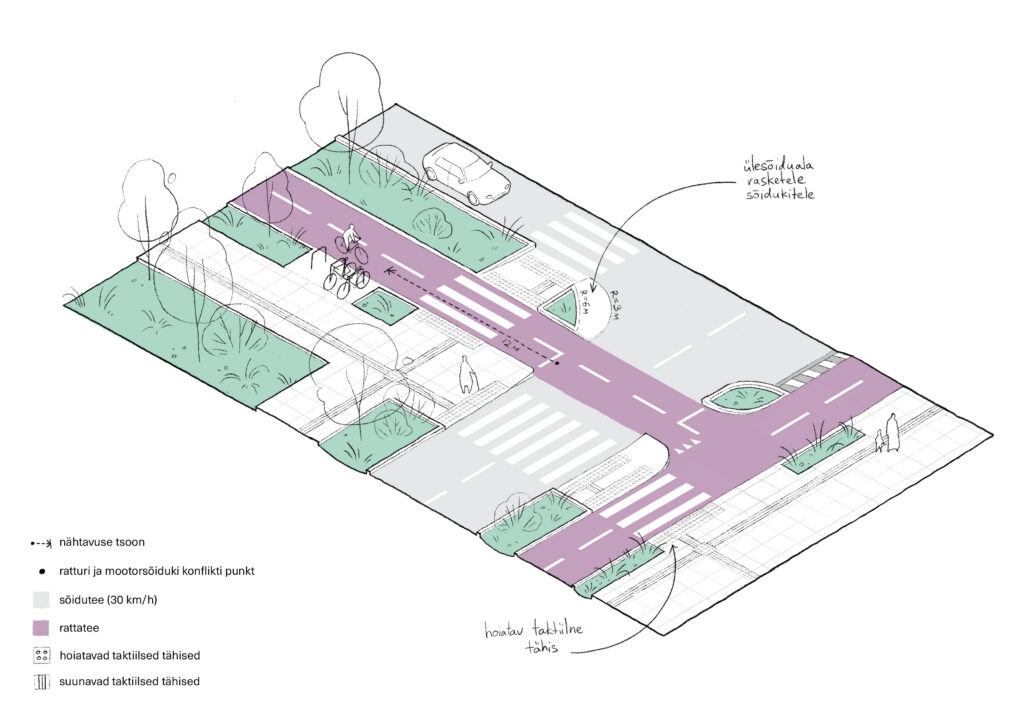
Crossings should work for pedestrians first, meaning direct routes with no unnecessary detours. We use tactile warning paving at crossing points to signal the start of the roadway and guide people with visual impairments to the right spot. Crossings must follow the sidewalk alignment as closely as possible and be spaced no more than 80–100 metres apart; a gap of more than 200 metres is not permitted.
Junction geometry matters for speed. Tighter turning radii force drivers to slow down before turning, bring crossing points closer to the centre of the junction and improve sightlines in both directions, making junctions safer for everyone. Raised crossings work on the same principle: the driver gets a physical and visual cue that they are moving into pedestrian territory. On neighbourhood streets, where traffic is slow and there are many pedestrians, raised crossings are the preferred solution.
A living document
This street design guide is a working document, and we expect it to develop as we learn what works in practice, how people actually use the spaces we create, and what new knowledge and experience brings.
The illustrations in the article show one possible approach for each street type. Final solutions will be developed through the design process with landscape architects, shaped by the specific character of each street.
